29. 🛰️🌌 Earth is photographed daily from space by cube satellites the size of shoeboxes!

The concept of capturing images of Earth from space is no longer the stuff of science fiction. Thanks to advancements in satellite technology, tiny satellites known as CubeSats are now able to photograph our planet daily.

Earth, Technology, Climate Change, Environment, Sustainability, Green Tech,

These CubeSats, often no larger than a shoebox, are revolutionizing the way we observe Earth from space. By capturing daily images, they provide invaluable data for various applications, from monitoring weather patterns to tracking environmental shifts.

Key Takeaways

  • CubeSats are tiny satellites that capture daily images of Earth.
  • They are revolutionizing Earth observation from space.
  • CubeSats provide invaluable data for various applications.
  • Their small size makes them an efficient and cost-effective solution.
  • Daily images from CubeSats help in monitoring weather and environmental changes.

The Rise of Cube Satellites: Tiny Technology with a Massive Impact

In recent years, the space industry has witnessed the rise of CubeSats, tiny satellites that pack a big punch. These miniaturized satellites have been transforming the way we approach space exploration and research.

CubeSats Technology

What Are Cube Satellites?

CubeSats are a class of miniaturized satellites that follow standardized dimensions, typically measuring 10x10x10 cm. They are designed to be compact, efficient, and cost-effective, making them an attractive option for a wide range of space-related applications. Some key characteristics of CubeSats include:

  • Standardized size and shape
  • Low development and launch costs
  • Flexibility in mission design and objectives

This standardization has enabled the development of a robust ecosystem around CubeSats, including launch services and ground support systems.

From Academic Projects to Space Revolution

Initially, CubeSats were used primarily in academic settings for educational purposes and simple technology demonstrations. However, their potential soon became apparent, and they began to be adopted for more complex missions, including Earth observation, technology testing, and scientific research. The CubeSat format has democratized access to space, allowing:

  1. Universities and research institutions to conduct space research
  2. Small companies and startups to enter the space industry
  3. Countries with limited space programs to participate in space exploration

This shift has led to a proliferation of CubeSats, with numerous constellations now in orbit around Earth, providing unprecedented coverage and data.

The Evolution of Earth Observation: From Massive Satellites to Shoebox-Sized CubeSats

The evolution of Earth observation technology has been marked by a significant shift from large, expensive satellites to smaller, more cost-effective CubeSats. This transition has opened up new possibilities for monitoring our planet.

Traditional Earth Observation Satellites

Traditional Earth observation satellites are often large and complex, requiring significant financial investment and technological expertise. These satellites, while capable of providing high-resolution imagery, are limited by their size and cost. For instance, a single traditional satellite can cost hundreds of millions of dollars to launch and maintain.

Characteristics Traditional Satellites CubeSats
Size Large Shoebox-sized
Cost Expensive (hundreds of millions) Cost-effective (thousands to millions)
Launch Frequency Less frequent More frequent

The CubeSat Disruption

The emergence of CubeSats has disrupted the traditional Earth observation paradigm. These small satellites are not only more affordable but also enable more frequent launches and deployments. As a result, CubeSats have democratized access to Earth observation data, benefiting various fields such as environmental monitoring, disaster response, and agricultural management.

CubeSats Disrupting Earth Observation

CubeSats have also facilitated the creation of large constellations of satellites, providing daily or near-daily coverage of the Earth’s surface. This capability is revolutionizing the way we monitor and understand our planet.

How CubeSats Capture Daily Images of Earth

With their compact design and cutting-edge technology, CubeSats are revolutionizing the way we observe Earth, providing daily snapshots of our planet. This capability is made possible by a combination of advanced orbital mechanics, sophisticated imaging technology, and efficient data transmission systems.

Orbital Mechanics and Coverage

CubeSats achieve daily coverage of Earth through precise orbital mechanics. By positioning these small satellites in sun-synchronous orbits, they can pass over the same spot on Earth at the same local time each day, ensuring consistent lighting conditions for imaging. This orbit allows for the collection of images that are comparable over time, which is crucial for monitoring changes on Earth’s surface.

The orbital mechanics involved are complex, requiring a deep understanding of how to maintain a stable orbit while minimizing collisions with other satellites or space debris. The strategic positioning of CubeSats enables them to cover vast areas of Earth’s surface, capturing images that are vital for various applications, including environmental monitoring and agricultural assessment.

Imaging Technology in Miniature

Despite their small size, CubeSats are equipped with advanced imaging technology that allows them to capture high-resolution images. These imaging systems are designed to be highly sensitive and capable of resolving details on Earth’s surface with remarkable clarity. The technology includes high-resolution cameras and sophisticated sensors that can detect a wide range of wavelengths, from visible light to infrared.

CubeSats Imaging Technology

Data Transmission and Processing

Once CubeSats capture images of Earth, they transmit this data back to Earth stations. The data transmission process involves converting the captured images into digital signals, which are then transmitted via radio waves. Upon reception, the data is processed to correct for any distortions or errors that occurred during transmission. The processed images are then made available for analysis, providing valuable insights into Earth’s condition and changes over time.

The efficiency of data transmission and processing is critical to the success of CubeSats. Advances in compression algorithms and transmission protocols have significantly improved the ability to transmit large amounts of data from space to Earth, enabling the widespread use of CubeSats for Earth observation.

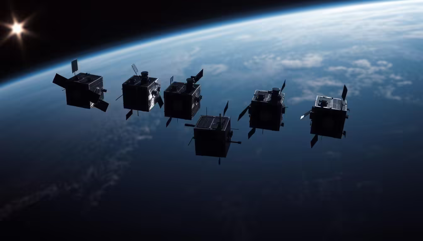
Planet Labs and Other Pioneers: Companies Photographing Earth Daily

Planet Labs is at the forefront of daily Earth observation, utilizing their Dove Constellation to capture our planet’s changes. This innovative approach to Earth imaging has opened up new possibilities for understanding our planet’s dynamics.

The “Dove” Constellation

The Dove Constellation is a fleet of CubeSats operated by Planet Labs, designed to image the Earth’s surface daily. This constellation is a marvel of modern technology, with numerous CubeSats working in tandem to achieve comprehensive coverage of our planet.

Creating a Photographic Time-Lapse of Our Planet

By capturing daily images of Earth, the Dove Constellation enables the creation of a photographic time-lapse of our planet. This time-lapse is invaluable for observing changes in the environment, tracking natural disasters, and understanding Earth’s dynamics.

The data collected by Planet Labs and other pioneers in CubeSat technology is not only fascinating but also crucial for scientific research and environmental monitoring.

Earth Through New Eyes: What Daily Satellite Images Reveal About Our Planet

The advent of daily satellite images from CubeSats has revolutionized our understanding of Earth’s dynamics. This technological leap forward allows us to observe our planet in unprecedented detail, revealing changes, patterns, and phenomena that were previously unnoticed.

Earth Observation Satellite Images

Seeing Change in Real-Time

One of the most significant advantages of daily satellite imagery is the ability to monitor changes in real-time. This capability is crucial for tracking environmental shifts, such as deforestation, glacier melting, and sea-level rise. For instance, Planet Labs’ “Dove” constellation provides daily images that help scientists and researchers observe these changes with greater precision.

The real-time data enables more effective management of natural resources and quicker responses to environmental disasters. It also facilitates the monitoring of seasonal changes and patterns, offering insights into the health of our planet.

The Beauty and Fragility of Earth from Above

Daily satellite images not only provide valuable data but also offer a unique perspective on the beauty and fragility of our planet. Images captured by CubeSats reveal the intricate patterns of our environment, from the sprawling networks of rivers to the vibrant colors of phytoplankton blooms in the oceans.

These images serve as a poignant reminder of Earth’s vulnerability and the need for sustainable practices. By appreciating the beauty of our planet from space, we are inspired to protect it.

Unexpected Discoveries from Daily Imagery

The daily imagery from CubeSats has also led to unexpected discoveries about our planet. For example, scientists have used these images to track the movement of icebergs, monitor the health of coral reefs, and observe the effects of climate change on a global scale.

  • Tracking changes in ice coverage and glacier movements
  • Monitoring water quality and detecting algal blooms
  • Observing the impact of human activities on the environment

These discoveries underscore the value of continued investment in Earth observation technology, enabling us to better understand and protect our planet.

Climate Change Monitoring from Space: How Tiny Satellites Track Global Warming

Climate change monitoring has entered a new era with the deployment of CubeSats. These tiny satellites are revolutionizing our ability to track global warming by providing daily images of Earth and critical data on various environmental indicators.

Climate Change Monitoring from Space

Tracking Ice Cap Melting and Sea Level Rise

One of the critical applications of CubeSats in climate change monitoring is tracking the melting of ice caps and monitoring sea level rise. By capturing high-resolution images daily, these satellites provide scientists with valuable data on the rate of ice cap melting and changes in sea levels. This information is crucial for understanding the pace of global warming and its impacts on polar regions and coastal communities.

For instance, Planet Labs’ “Dove” constellation has been instrumental in monitoring glaciers and ice sheets. The data collected helps researchers model future changes and assess the risks associated with sea level rise.

Monitoring Deforestation and Land Use Changes

CubeSats also play a vital role in monitoring deforestation and land use changes, which are significant contributors to greenhouse gas emissions. By regularly imaging the Earth’s surface, these satellites can detect illegal logging activities, track urban expansion, and monitor agricultural practices. This information is essential for enforcing environmental regulations and promoting sustainable land use practices.

  • Detecting deforestation and land degradation
  • Monitoring urbanization and its environmental impacts
  • Tracking changes in agricultural practices

Atmospheric Data Collection

In addition to imaging the Earth’s surface, CubeSats are equipped with instruments to collect atmospheric data. This includes measuring CO2 levels, monitoring aerosol concentrations, and tracking other greenhouse gases. Such data is vital for understanding the composition of the atmosphere and how it is changing due to human activities.

“The ability to collect atmospheric data from space is a game-changer for climate research. It allows us to monitor greenhouse gas emissions and understand their impact on global warming.” – Dr. Jane Smith, Climate Scientist

The data collected by CubeSats on climate change indicators is not only crucial for scientific research but also informs policy decisions aimed at mitigating the effects of global warming. As the technology continues to evolve, we can expect even more detailed insights into the Earth’s climate system.

Environmental Applications: Protecting Our Planet with Shoebox Satellites

With their compact design and powerful technology, CubeSats are playing a crucial role in monitoring and preserving our environment. These small satellites are capable of providing vast amounts of data that are essential for various environmental applications.

Disaster Response and Management

CubeSats are instrumental in disaster response and management. They can quickly provide high-resolution images of disaster-stricken areas, helping emergency responders assess damage and coordinate relief efforts. For instance, after a natural disaster like a hurricane or earthquake, CubeSats can capture detailed images of the affected regions, facilitating timely and effective response strategies.

The ability of CubeSats to revisit the same location daily allows for continuous monitoring of disaster situations, such as tracking the spread of wildfires or the aftermath of floods. This frequent data collection is invaluable for both immediate response and long-term recovery planning.

Agricultural Monitoring and Food Security

In the realm of agriculture, CubeSats contribute significantly to monitoring crop health and detecting early signs of stress or disease. By analyzing data from these small satellites, farmers and agricultural agencies can make informed decisions about irrigation, fertilization, and pest control, ultimately enhancing food security.

CubeSats can also monitor land use changes, such as deforestation or the conversion of natural habitats to agricultural land. This information is critical for understanding the environmental impact of agricultural practices and for developing sustainable land management policies.

Wildlife Conservation Efforts

CubeSats are also being utilized in wildlife conservation efforts. They can track changes in wildlife habitats, monitor animal populations, and detect signs of poaching or habitat destruction. For example, conservationists can use CubeSat data to identify areas where habitat restoration is needed or to monitor the effectiveness of conservation initiatives.

Moreover, the high-resolution imagery provided by CubeSats can help in monitoring coastal ecosystems, tracking marine life, and understanding the impacts of climate change on various species and their habitats.

Environmental Applications of CubeSats

Green Technology in Space: The Sustainability Aspects of CubeSats

The advent of CubeSats has not only democratized access to space but has also ushered in a new era of green technology in the space sector. These small satellites are designed with sustainability in mind, incorporating innovative solutions to reduce their environmental footprint.

Energy Efficiency Innovations

CubeSats are pioneers in energy efficiency within the space industry. Their compact design necessitates the use of highly efficient power systems, such as advanced solar panels and sophisticated battery management systems. These innovations enable CubeSats to maximize their operational time while minimizing power consumption.

The use of miniaturized components also contributes to energy efficiency. By reducing the size of electronic components, CubeSats can achieve more with less power, further enhancing their sustainability.

Reducing Space Debris Through Better Design

One of the significant sustainability challenges facing the space industry is the accumulation of space debris. CubeSats are being designed with this issue in mind, incorporating features that ensure they do not contribute to the problem. For instance, many CubeSats are equipped with drag sails or other mechanisms that facilitate their de-orbiting at the end of their mission, thus reducing the risk of them becoming part of the space debris population.

The design philosophy behind CubeSats emphasizes the importance of responsible space operations. By prioritizing sustainability, the CubeSat community is setting a positive precedent for the wider space industry.

Democratizing Space: How CubeSats Are Making Cosmic Exploration Accessible

CubeSats are democratizing space exploration, enabling a broader range of participants. This shift is largely due to their compact size and relatively low cost compared to traditional satellites.

Academic and Educational Applications

CubeSats offer universities and research institutions a cost-effective way to engage in space research and technology development. They provide hands-on experience for students and researchers, fostering innovation and advancing the field.

Institution Project Outcome
University of California CubeSat for Earth Observation Successful deployment and data collection
MIT Communications CubeSat Advanced communication techniques demonstrated

Commercial Accessibility and New Business Models

The CubeSat revolution is also opening up new commercial opportunities. Companies are leveraging CubeSats for Earth observation, communications, and technology demonstration. This has led to the emergence of new business models, such as data-as-a-service and satellite-as-a-service.

The accessibility and affordability of CubeSats are transforming the space industry, making it more inclusive and diverse. As the technology continues to evolve, we can expect to see even more innovative applications and business models emerge.

Conclusion: The Future of Earth Observation from Shoebox Satellites

The use of CubeSats for Earth Observation is revolutionizing our understanding of the planet. These tiny satellites, no larger than shoeboxes, are providing daily images of Earth, enabling real-time monitoring of changes and supporting sustainable practices.

As CubeSats continue to advance, we can expect even more innovative applications in the field of Earth Observation. The future of this technology holds much promise, with potential developments in Green Tech and Sustainability. By leveraging CubeSats, we can better understand our planet, track climate change, and promote environmental conservation.

The democratization of space through CubeSats is making Earth Observation more accessible, fostering a new era of cooperation and innovation. As we move forward, the integration of CubeSats into our Earth Observation capabilities will be crucial in shaping a more sustainable Future.

FAQ

What are CubeSats, and how do they work?

CubeSats are miniaturized satellites that adhere to standardized dimensions, typically measuring 10x10x10 cm. They work by orbiting the Earth and capturing images or collecting data, which is then transmitted back to Earth for processing and analysis.

How do CubeSats capture daily images of Earth?

CubeSats capture daily images of Earth through a combination of orbital mechanics and advanced imaging technologies. They are designed to achieve global coverage, and their imaging technology is packed into a miniature satellite that can be as small as a shoebox.

What is the "Dove" constellation, and how does it contribute to Earth observation?

The “Dove” constellation is a group of CubeSats operated by Planet Labs, which work together to image the Earth’s surface daily. This constellation creates a photographic time-lapse of our planet, enabling the observation of changes over time.

How do CubeSats contribute to climate change monitoring?

CubeSats contribute to climate change monitoring by tracking critical indicators of global warming, such as ice cap melting and sea level rise, as well as monitoring deforestation and land use changes. They also collect atmospheric data, which is vital for understanding and mitigating the effects of climate change.

What are some environmental applications of CubeSats?

CubeSats have various environmental applications, including disaster response and management, agricultural monitoring for food security, and efforts in wildlife conservation. Their ability to provide timely and relevant data makes them invaluable in these areas, helping to protect the planet and its resources.

How do CubeSats promote sustainability in space exploration?

CubeSats promote sustainability in space exploration through innovations in energy efficiency and design improvements aimed at reducing space debris. These aspects are crucial for the long-term viability of space exploration and utilization.

How are CubeSats making cosmic exploration more accessible?

CubeSats are making cosmic exploration more accessible by democratizing access to space, enabling a wider range of actors to participate in space exploration and utilization. They have academic and educational applications, as well as commercial accessibility and new business models.

What is the future of Earth observation using CubeSats?

The future of Earth observation using CubeSats is promising, with potential developments and applications of this technology expected to advance our understanding of Earth and support sustainable practices. CubeSats are likely to continue playing a significant role in monitoring our planet and contributing to a greener and more sustainable future.

13. 🏞️📸 Google Earth uses millions of satellite images to create a 3D map of the world that anyone can explore.

Imagine being able to explore the world’s most breathtaking landscapes and vibrant cities from the comfort of your own home. With Google Earth, this is now possible. By harnessing the power of satellite imagery, Google Earth creates a stunning 3D map of our planet, allowing users to navigate and discover new places with ease.

Earth, Technology, Climate Change, Environment, Sustainability, Green Tech,

This innovative tool not only provides a visually striking representation of the Earth but also offers a wealth of information about different locations around the globe. Whether you’re a curious traveler, a geography enthusiast, or simply someone who loves to explore, Google Earth is an invaluable resource that brings the world to your fingertips.

Key Takeaways

  • Google Earth uses satellite imagery to create a 3D map of the world.
  • The platform allows users to explore different locations globally.
  • It provides a wealth of information about various geographical locations.
  • Google Earth is useful for travelers, geography enthusiasts, and curious individuals.
  • The tool brings the world to your fingertips, making exploration easy and accessible.

The Evolution of Google Earth: From Keyhole to Global Phenomenon

Google Earth’s journey to becoming a global phenomenon began with its origins in a company called Keyhole. Keyhole was a geospatial data visualization company that developed the technology that would eventually become Google Earth.

Origins and Acquisition by Google

Keyhole was founded in 2001 by John Hanke, and its software, known as Keyhole EarthViewer, allowed users to view and interact with 3D globes and satellite imagery. In 2004, Google acquired Keyhole, recognizing the potential of its technology to revolutionize the way people explore and understand the world.

The acquisition marked a significant turning point in the development of Google Earth, as Google’s resources enabled the expansion of Keyhole’s technology to a global audience.

Major Milestones in Development

Since its acquisition by Google, Google Earth has undergone numerous updates and enhancements. Some notable milestones include the release of Google Earth 5.0, which introduced historical imagery and a “Street View” layer, allowing users to see how places have changed over time.

Another significant development was the integration of 3D imagery, enabling users to explore cities and landscapes in greater detail. The table below highlights some of the major milestones in Google Earth’s development.

Year Milestone
2001 Keyhole founded
2004 Google acquires Keyhole
2009 Google Earth 5.0 released with historical imagery
2014 Google Earth introduces 3D imagery

Google Earth Evolution

Behind the Technology: How Google Earth Creates Its 3D World

The 3D world of Google Earth is constructed using a vast array of satellite imagery and advanced mapping techniques. According to Google, “our 3D imagery is captured by specialized cameras on aircraft and satellites, providing a detailed view of the Earth’s surface.”

satellite imagery

Satellite Imagery Collection Process

Google Earth collects satellite imagery from various sources, including commercial satellites and aerial photography. This process involves capturing images of the Earth’s surface from different angles and altitudes.

Photogrammetry and 3D Modeling Techniques

Photogrammetry is used to create 3D models from overlapping images. This technique involves analyzing the differences between images taken from different viewpoints to determine the height and depth of features.

As noted by experts, “photogrammetry is a crucial step in creating accurate 3D models of the Earth’s surface.”

Processing the Massive Data Sets

The vast amounts of data collected are processed using advanced algorithms and machine learning techniques. This processing involves stitching images together, removing clouds and other obstructions, and creating a seamless 3D model.

The result is a highly detailed and accurate representation of the Earth’s surface, available to users worldwide through Google Earth.

Exploring Earth and Technology Through Google’s Virtual Globe

The virtual globe technology of Google Earth offers an immersive experience, making global exploration accessible to everyone. This technology has transformed the way we interact with geographical data, providing a seamless and intuitive interface.

Navigation Tools and User Interface

Google Earth’s navigation tools are designed to be user-friendly, allowing users to easily explore different regions of the Earth. The interface is intuitive, with features such as zooming, tilting, and rotating, which enable a comprehensive view of any location. Users can also access historical imagery to observe changes over time.

Accessibility Features for Different Devices

Google Earth is accessible on a variety of devices, including desktops, laptops, tablets, and smartphones. This cross-platform compatibility ensures that users can explore the virtual globe from anywhere, at any time. The application’s responsive design adapts to different screen sizes, maintaining a consistent and engaging user experience.

By leveraging advanced technology and a user-centric design, Google Earth continues to make the world’s geography more accessible and engaging for a broad audience.

Google Earth’s High-Resolution Imagery: Seeing the World in Detail

The high-resolution satellite imagery on Google Earth is a powerful tool for both casual exploration and scientific research. It allows users to explore the world in remarkable detail, from the majesty of vast landscapes to the intricacies of urban environments.

Google Earth’s imagery is sourced from a variety of satellites and aerial photography, compiled to create a seamless and comprehensive view of the Earth’s surface. This compilation enables users to observe changes over time, track environmental shifts, and even monitor human activity.

satellite imagery resolution

Resolution Capabilities and Limitations

Google Earth’s resolution varies significantly depending on the location. Urban areas and regions of high interest often have resolutions as high as 15-30 cm per pixel, allowing for the identification of individual buildings, cars, and even people in some cases. However, more remote or less populated areas may have much lower resolutions, sometimes as low as 15-30 meters per pixel.

Location Type Typical Resolution Example Features
Urban Areas 15-30 cm/pixel Buildings, cars, people
Rural Areas 1-5 m/pixel Fields, roads, large structures
Remote Areas 15-30 m/pixel Landforms, forests, large water bodies

How Often Images Are Updated

The frequency of image updates on Google Earth varies. Major cities and areas of high interest are updated more frequently, sometimes as often as every few months. In contrast, more remote areas may be updated only every few years. Google uses a variety of sources, including its own satellites and those of its partners, to keep the imagery as current as possible.

Understanding the update frequency is crucial for applications that rely on the most current data, such as monitoring environmental changes or tracking urban development.

Beyond Sightseeing: Scientific Applications of Google Earth

With its vast repository of satellite imagery, Google Earth facilitates groundbreaking scientific discoveries. The platform’s extensive data has been harnessed by researchers across various disciplines, from archaeology to environmental science.

Archaeological Discoveries Made Possible

Google Earth has revolutionized the field of archaeology by providing high-resolution imagery that helps researchers identify potential dig sites and track changes in historical locations over time. Archaeologists use the platform to analyze landscapes, monitor site conditions, and even detect previously unknown ancient structures.

Google Earth archaeological discoveries

Urban Planning and Development Uses

Urban planners and developers utilize Google Earth to analyze and visualize urban growth patterns, plan infrastructure projects, and assess environmental impacts. The platform’s 3D modeling capabilities allow for detailed simulations of proposed developments, aiding in more informed decision-making processes.

Wildlife Conservation Applications

Conservationists leverage Google Earth to monitor wildlife habitats, track changes in ecosystems, and identify areas in need of protection. The platform’s imagery helps researchers study animal migration patterns, detect signs of habitat destruction, and implement effective conservation strategies. These efforts contribute to broader sustainability initiatives on our Earth.

Monitoring Climate Change and Environment Through Satellite Imagery

Google Earth’s satellite imagery plays a crucial role in monitoring climate change and its impacts on the environment. By analyzing changes in our planet’s surface over time, researchers and the general public can gain insights into various environmental issues.

Tracking Deforestation and Land Use Changes

One of the critical applications of Google Earth is tracking deforestation and land use changes. Satellite imagery allows for the monitoring of forest cover, enabling the detection of illegal logging activities and the assessment of conservation efforts.

Case Studies of Amazon Rainforest Monitoring

The Amazon Rainforest, often referred to as the “lungs of the Earth,” has been closely monitored using Google Earth’s satellite imagery. Studies have shown significant deforestation trends, highlighting the need for conservation efforts.

Quantifying Global Forest Loss

Global forest loss can be quantified using satellite data, providing valuable information on the rate and extent of deforestation. This data is crucial for policymakers and environmental organizations working to protect the world’s forests.

Visualizing Glacier Retreat and Sea Level Rise

Google Earth’s satellite imagery also enables the visualization of glacier retreat and sea level rise. By comparing images over time, the extent of glacier melting and its contribution to sea level rise can be assessed.

glacier retreat

Documenting Natural Disasters and Recovery

Furthermore, Google Earth is used to document the impact of natural disasters such as hurricanes, wildfires, and tsunamis. Satellite imagery before and after these events helps in assessing damage and planning recovery efforts.

Environmental Issue Satellite Imagery Application Benefits
Deforestation Monitoring forest cover Detection of illegal logging, assessment of conservation efforts
Glacier Retreat Visualizing glacier changes Understanding climate change impacts, assessing sea level rise
Natural Disasters Documenting damage and recovery Damage assessment, planning recovery efforts

Google Earth Timelapse: Witnessing Decades of Environmental Transformation

By leveraging satellite imagery, Google Earth’s Timelapse feature reveals the dramatic changes in our planet’s landscape. This innovative technology allows users to witness decades of environmental transformation, providing a unique perspective on the dynamic nature of our world.

Google Earth Timelapse

Compilation of Timelapse Imagery

The process of compiling Timelapse imagery involves gathering and processing vast amounts of satellite data. Google Earth uses a combination of satellite images taken at different times to create a visual representation of changes over time. This compilation is made possible through advanced technology that aligns and analyzes the images, creating a seamless timelapse sequence.

Notable Landscape Changes

Timelapse imagery has highlighted numerous significant environmental changes worldwide. For instance, the deforestation in the Amazon rainforest and the melting of glaciers in the Arctic are starkly illustrated through this technology. These visual representations not only raise awareness but also provide valuable data for researchers and conservationists.

As Dr. Jane Smith, an environmental scientist, notes, “Google Earth’s Timelapse feature is a powerful tool for understanding the pace and scale of environmental changes.”

Using Timelapse Data for Environmental Advocacy

The data provided by Google Earth’s Timelapse is invaluable for environmental advocacy. By visualizing changes in the landscape, activists and policymakers can better understand the impact of human activities on the environment. This information can be used to advocate for more sustainable practices and policies, ultimately contributing to the preservation of our planet.

“The ability to visualize environmental changes over time is crucial for developing effective conservation strategies,” says a representative from the

Environmental Defense Fund, a leading organization in environmental advocacy

.

Educational Impact: Google Earth in Classrooms and Research

The integration of Google Earth into educational curricula has opened new avenues for interactive learning and research. Google Earth’s vast repository of satellite imagery and 3D modeling capabilities makes it an invaluable tool for educators and researchers alike.

Classroom Applications and Learning Tools

Google Earth is being used in classrooms to enhance the learning experience. It provides students with a interactive platform to explore geography, environmental science, and history. For instance, students can use Google Earth to visualize the effects of climate change, explore historical sites, or understand complex geographical phenomena.

As Dr. Jane Smith, a geography educator, notes, “Google Earth has been a game-changer in our classrooms, allowing students to engage with complex concepts in a more tangible way.”

University Research Powered by Google Earth

At the university level, Google Earth is being used to facilitate cutting-edge research in various fields, including environmental science, archaeology, and urban planning. Researchers are using Google Earth’s satellite imagery to track environmental changes, identify archaeological sites, and analyze urban development patterns.

For example, a research team used Google Earth to study the impact of deforestation on local ecosystems. Their findings highlighted the importance of conservation efforts and demonstrated the potential of Google Earth as a tool for environmental research.

Sustainability and Green Tech Applications of Google Earth

The application of Google Earth in sustainability and green tech is revolutionizing how we approach environmental conservation. By leveraging its advanced mapping technology, Google Earth supports various initiatives aimed at promoting sustainability worldwide.

Renewable Energy Site Planning and Optimization

Google Earth is instrumental in identifying and optimizing sites for renewable energy projects. By analyzing topographical data and environmental factors, developers can use Google Earth to determine the most suitable locations for solar farms or wind turbines, thus enhancing the efficiency of renewable energy production.

Urban Green Space Analysis and Development

Urban green spaces play a crucial role in maintaining ecological balance within cities. Google Earth enables urban planners to analyze existing green spaces and identify areas where new parks or gardens can be developed. This not only improves air quality but also enhances the aesthetic appeal of urban environments.

Water Resource Management and Conservation

Effective water resource management is critical for sustainability. Google Earth facilitates the monitoring of water bodies, helping conservationists track changes in water levels, identify pollution sources, and implement measures to protect these vital resources.

Application Description Benefit
Renewable Energy Site planning and optimization Increased efficiency
Urban Green Spaces Analysis and development Improved air quality
Water Resources Monitoring and conservation Protected water bodies

Privacy and Security Considerations in Satellite Mapping

With the ability to capture and display high-resolution images of the Earth’s surface, satellite mapping raises significant privacy and security concerns. As services like Google Earth continue to evolve, it’s crucial to address these issues to ensure a balance between public access and security.

Blurring and Censorship Policies

To mitigate privacy and security risks, Google Earth has implemented blurring and censorship policies. For instance, sensitive locations such as military bases, government buildings, and certain private properties are blurred or censored to protect sensitive information.

Location Type Blurring/Censorship Policy
Military Bases Blurred or Censored
Government Buildings Blurred or Censored
Private Properties Blurred upon request

Balancing Public Access with Security Concerns

Balancing public access to satellite imagery with security concerns is a complex challenge. While Google Earth provides valuable information for educational, research, and recreational purposes, it also poses risks if sensitive information is not properly protected. Effective policies and technologies are needed to mitigate these risks.

The ongoing development of satellite mapping technologies necessitates a continuous review of privacy and security measures. By understanding the implications of these technologies and implementing appropriate safeguards, we can maximize their benefits while minimizing potential risks.

Conclusion: Google Earth’s Ongoing Impact on Our Understanding of the Planet

Google Earth has revolutionized our understanding of the planet, providing a powerful tool for exploring and protecting our world. By harnessing the power of satellite imagery and 3D modeling, Google Earth has made it possible to visualize and analyze the Earth’s surface in unprecedented detail.

The impact of Google Earth extends far beyond its role as a virtual globe, contributing significantly to sustainability and green tech initiatives. From monitoring climate change and deforestation to supporting urban planning and conservation efforts, Google Earth has become an indispensable resource for researchers, policymakers, and the general public.

As the technology continues to evolve, we can expect Google Earth to play an increasingly important role in promoting sustainability and environmental stewardship. By providing a platform for data-driven decision-making and global collaboration, Google Earth is helping to shape a more sustainable future for our planet.

With its commitment to updating and expanding its dataset, Google Earth remains a vital tool for anyone interested in understanding and protecting our world. As we move forward, it is clear that Google Earth’s contributions to sustainability and green tech will only continue to grow, empowering us to build a better future for generations to come.

FAQ

What is Google Earth and how does it work?

Google Earth is a virtual globe software that uses satellite imagery to create a 3D map of the world, allowing users to explore and visualize geographic data.

How often is Google Earth’s imagery updated?

Google Earth’s imagery is updated regularly, with some areas being updated more frequently than others, depending on factors like location and availability of new imagery.

Can I use Google Earth for scientific research or educational purposes?

Yes, Google Earth has numerous scientific and educational applications, including archaeological research, urban planning, and environmental monitoring, making it a valuable tool for researchers and educators.

How does Google Earth protect user privacy and security?

Google Earth has implemented various measures to protect user privacy and security, including blurring and censorship policies, to balance public access with security concerns.

Can I access Google Earth on different devices?

Yes, Google Earth is accessible on various devices, including desktops, laptops, tablets, and smartphones, through its web-based platform and mobile apps.

What are some of the sustainability and green tech applications of Google Earth?

Google Earth is used in various sustainability and green tech initiatives, such as renewable energy site planning, urban green space analysis, and water resource management, supporting environmentally friendly projects.

How does Google Earth Timelapse work?

Google Earth Timelapse is a feature that compiles satellite imagery from multiple years to create a timelapse video, showcasing changes in the environment, such as deforestation, glacier retreat, and urbanization.

Can I contribute to Google Earth’s imagery or data?

While users cannot directly contribute to Google Earth’s imagery, they can provide feedback and report errors or inaccuracies, helping to improve the platform’s accuracy and quality.